About

Geomatics Engineer | GIS Specialist
A highly motivated Geomatics Engineer with strong academic standing and multidisciplinary experience in Remote Sensing, GIScience, Earth Observation technologies, UAV & LiDAR data processing, geospatial modelling, survey engineering, and web-based geospatial systems. Skilled in applying computational tools, including Python, Google Earth Engine, PostgreSQL/PostGIS, and machine learning techniques, to environmental analysis, infrastructure mapping, and spatial decision-making.
- Degree: Bachelor in Geomatics Engineering
- Address: Panauti, Nepal
- Email: monika.manandhar.geo@gmail.com
- Language: Nepal Bhasa, Nepali, English, Hindi
Paper Published
Projects Completed
Years of Experience
Skills
GIS Analysis
95%Field Survey (Ground and Aerial)
85%WebGIS Platfrom
80%HTML & CSS
75%Python
40%Remote Sensing, Drones, Photogrammetry
50%Resume
Professional Summary
A highly motivated Geomatics Engineer with strong academic performance and multidisciplinary experience in remote sensing, GIS, earth observation, UAV & LiDAR data processing, and geospatial modeling. Proficient in Python, Google Earth Engine, PostgreSQL/PostGIS, and machine learning for environmental analysis, infrastructure mapping, and spatial decision-making.
Contact Information
- Panauti, Kavre
- monika.manandhar.geo@gmail.com
- https://www.linkedin.com/in/monika-manandhar/
Professional Experience
RESEARCH ASSOCIATE (GEOSPATIAL)
Jan 2026 - Present
Institute Of Himalayan Risk Reduction.
- Manage and analyze spatial datasets for Disaster Risk Reduction (DRR) projects.
- Perform advanced remote sensing analyses for hazard assessment and LULC mapping
- Integrate geospatial analyses into research, proposals, and knowledge products
- Create high-quality maps and visualizations for reporting and decision support
GIS and Mapping INSTRUCTOR
Nov 2025 - Present
Gyan Hub Pvt. Ltd.
- Conducted training for students and professionals in spatial data analysis, digitisation, geoprocessing, thematic mapping, and introductory cartographic design.
GIS ENGINEER
Jan 2025 - Jun 2025
Kathmandu Metropolitan City
- Worked in the "Road Naming and Mapping Project" under Kathmandu Metropolitan City.
- Develop WebGIS Portal and GIS Platform
- Supervised Junior Surveyors and conducted the Road Survey.
GEOMATICS ENGINEER
Aug 2024 - Jan 2025
NEA Engineering Company
- Worked on 220 kV & 400 kV transmission line projects and hydropower projects
- Conducted GNSS RTK, DGPS, and UAV LiDAR surveys
- Produced terrain models, orthomosaics, and alignment/ROW maps using AutoCAD Civil 3D
GEOMATICS INTERN
Aug 2024 - Jan 2025
NEA Engineering Company
- Assisted in field surveys, data processing, and AutoCAD drafting,
- Performing GIS and Surveying Activities
Education
Bachelor's in Geomatics Engineering
2019 - 2024
Kathmandu University
CGPA: 3.83/4.0
Relevant courses: Geographic Information System (GIS), Cartography, Geodesy, Surveying, Photogrammetry, Remote Sensing, Python, Precise Point Positioning.
Khwopa Secondary School
2017 - 2019
CGPA: 3.33/4.0
Relevant courses: Mathematics, Biology, Physics, Chemistry, English, Nepali
Siddhartha Vanasthali Institute
2003- 2017
CGPA: 3.59/4.00
Certificates

Project / Research
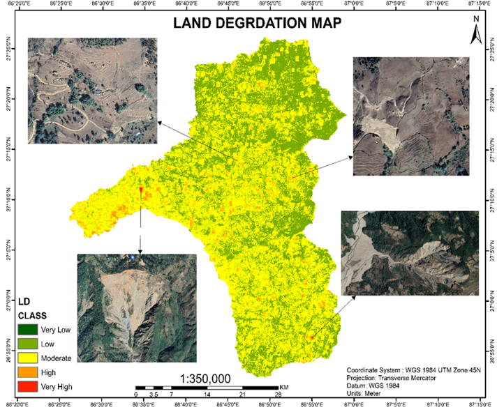
Assessment of land degradation in Khotang District using remote sensing and GIS
Read More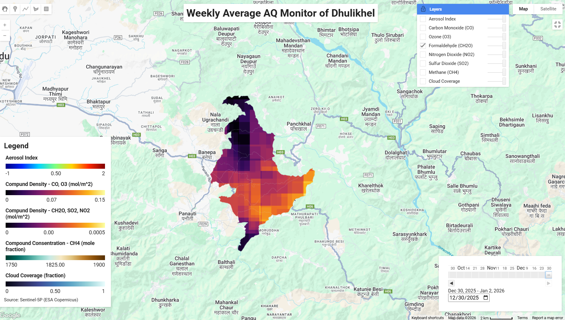
Interactive Weekly Air Quality Monitoring Dashboard for Dhulikhel Using Sentinel-5P on Google Earth Engine
Read More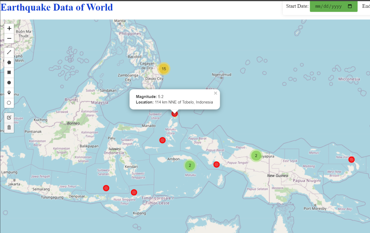
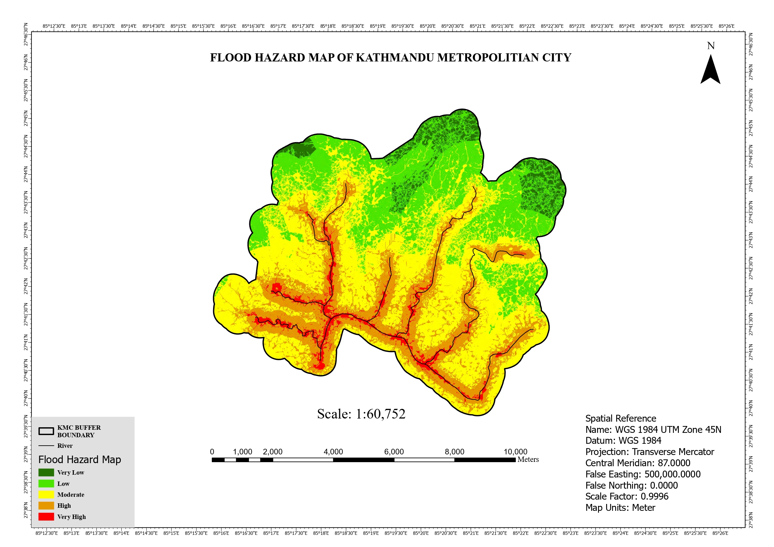
Flood Mapping Of Kathmandu Metropolitan City Read More
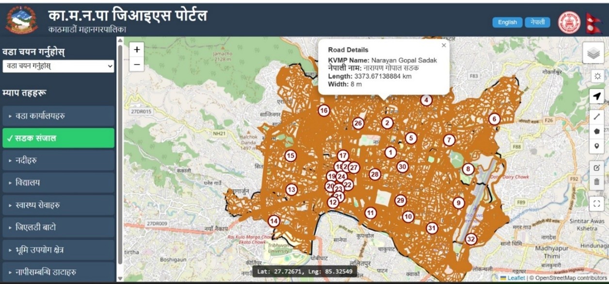
Web Application Portal Of Kathmandu Metropolitan City
Services
Specialising and
providing solutions.
Geospatial Analysis
I offer geospatial analysis services using Remote Sensing, Google Earth Engine, and various machine learning algorithms for data processing and decision-making. From land use classification to environmental monitoring, I can analyze spatial data to derive meaningful insights for research and project applications.
Web-GIS Design
Specialized in WebGIS design, creating interactive web maps for diverse applications. With experience in earthquake visualization, Integrated Municipal Systems, and the KMC Web Portal using Leaflet and other tools, I can develop user-friendly and efficient geospatial solutions tailored to project needs.
Field Survey
Experienced in conducting field surveys using advanced equipment such as Total Station, Drone, DGPS, LiDAR, and Plane Table, and many more. I provide precise data collection and mapping services for various projects, ensuring accuracy and efficiency in geospatial analysis.
GIS Mapping
I provide GIS mapping services for spatial data visualization, analysis, and decision-making. With expertise in creating detailed maps using satellite imagery, field data, and geospatial techniques, I develop accurate and interactive mapping solutions for various applications.
Land Measurement
I provide land measurement services, including precise area calculations, staking out points or plots, and parcel division. Using advanced surveying techniques and equipment, I ensure accurate boundary determination and land mapping for property management, construction, and development projects.